A business trip took me to Giurgui, on the Romanian bank of the Danube. I discovered a small city that’s a gateway to the much larger Bulgarian city of Ruse just opposite, dotted with fascinating reminders of earlier times.
I’d been working on an article on the Danube as a transport corridor. Europe’s second longest river, it runs through ten countries before emerging into the Black Sea not far from Romania’s border with Ukraine.
I talked to several people who told me that the river has the potential to offer cheap and convenient alternative to sea transport around Europe, but that due to poor maintenance and a lack of investment in infrastructure cargo transport on the Danube is falling.
However, I wanted to go and see for myself, so decided to take a bus to the town of Giurgui on the Romanian-Bulgarian border, just 60 kilometres from Bucharest.
How to get to Giurgui
I went there on a sopping wet Friday afternoon. Getting there was a challenge. There is a railway that connects the city to Bucharest, which was the first railway line built in Romania in 1869 and later extended to Smarda.
However, I’d heard that buses were both quicker and more frequent — provided I could find where to get one from. So to start the journey, first I had to get a taxi to take me to “the place where buses to Giurgui go to”, resisting his efforts to take me all the way by taxi.
I’m not sure exactly where the “the place where buses to Giurgui go to” was, just that it was somewhere in the southern part of the city, surrounded by apartment blocks. However, the direction clearly worked, because there was indeed a bus waiting to go to Giurgui.
A brief few minutes of sunshine showed the gloriously lush countryside as we exited Bucharest. The area around Giurgiu, the capital of Giurgui County and part of the historical region of Muntenia, is known for its rich grain production.
The town of about 60,000 people is surrounded by marshes and mudflats. Because of its location on the Danube, its economy has long been based on exports of goods such as timber, grain, salt, and petroleum and imports of coal, iron and textiles.
History of Giurgiu
The area around Giurgiu was heavily populated during the time of the Dacians. The capital of Burebista, a Dacian king, is believed to have been in this area, specifically in Popești on the Argeș River.
During Roman times, the area was the site of Theodorapolis, a city built by the emperor Justinian.
Present day Giurgiu was likely established in the 14th century as a port on the Danube River by Genoese merchants. They set up a bank and traded in silks and velvets.
It’s believed the city was named after the patron saint of Genoa, San Giorgio (St George), but some historians argue it’s an old Romanian form of George.
The city was conquered by the Ottomans in 1420 to control the Danube traffic. The Ottomans named the city Yergogu — probably because of the similarity between the pronunciation of Giorgio and Yergogu.
It was the site of several battles for control of the lower Danube, among them the October 1595 Battle of Giurgiu.
In 1771, the Ottomans built the historic Giurgiu Clocktower as a surveillance tower for Danube traffic.
Exploring in the rain
When my bus arrived at Giurgui’s gloomy outside bus station it was raining again.
Hungry, I ate a very late lunch at a pizza parlour. Somehow I had happened on a cafe that had attracted a handful of chain smoking “big guys” and glamorous girls.
While I appreciated Bucharest being so modern and European after my years in Central Asia, there was something about being in a provincial town with the local “big guys” that reminded me about being back in Kazakhstan.
Then the vegetarian pizza arrived with no cheese on, which was very disappointing.
Still, I ate it up and ordered a cappuccino while I surreptitiously watched the “big guys” and their girlfriends, and the rain running down the steamed up window, before heading out to explore.
The main site in downtown Giurgiu is the clock tower on central Piața Unirii in Giurgiu, which is the symbol of the city, prominent on its coat of arms.
It was originally fortified, but after the Ottomans were driven out, this construction underwent some changes and a clock was added.
It was overhauled in 2005-07, when a new clock was installed, while the original is kept in the nearby Teoharie Antonescu History Museum.
The Teoharie Antonescu History Museum
Set up in 1934, the museum was named after the first professor of archeology at the University of Iasi, Giurgiule Teohari Antonescu.
It’s still the town’s main museum, though there were a lot of changes during and after the communist era. From 1977 to 1990, its permanent exhibition was renamed “The Museum of the Struggle for the Independence of the Romanian People”, then since 1993, it has returned to its pre-war name.
Between 1999 and 2005, the exhibition of archeology and history was restored and in 2006, the ethnography section from Floresti-Stoeneşti was brought to Giurgiu, where a new permanent exhibition was opened.
There’s also the Giurgiu Diocese Museum, whose collection includes over 1,200 books and over 250 religious objects.
Churches and monasteries worth checking out include the Assumption of the Holy Virgin Cathedral, the Monastery of the Holy Great Martyr, the St Nicholas Monastery and the Annunciation Greek church.
Finding the Danube
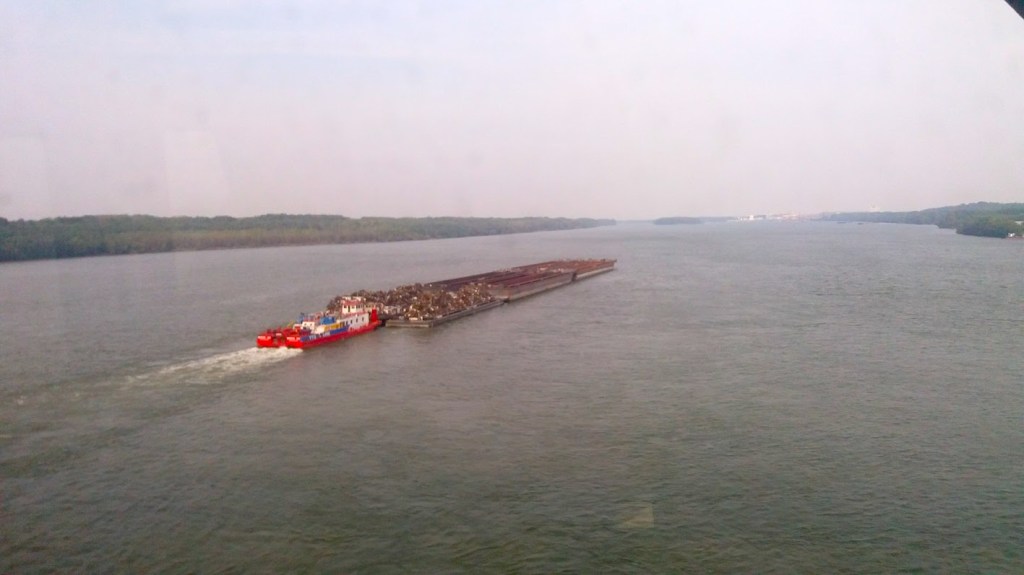
I was in Giurgiu to take a look at the port and the Danube. Unfortunately, there was no obvious access to the port and trudging around on foot the distances looked a lot further than they did on Google Maps.
The city sits on the left bank of the Danube river, opposite the Bulgarian city of Ruse, and is surrounded by marshes and mudflats. There is Smarda, a larger island in the river and three smaller islands are also visible from the city.
After tramping for half an hour along a largely disused lane, I eventually got to the port buildings and a smart looking riverside restaurant with several SUVs parked outside.
Peering through the trees, I could see a large expanse of grey-green water then the chimney stacks and apartment blocks of the much larger town of Ruse, Bulgaria’s fifth largest city.
There was also a good view of the Giurgiu-Ruse Friendship Bridge, which spans the Danube river and the Bulgarian-Romanian border. It was built in 1952-1954, during the communist regime and with help from the USSR.
I hadn’t managed to get anyone from the port authority on the phone, so after stood around damply taking some photographs then headed back.
The remains of Giurgiu Fortress
On the way back to the town I came across the remains of Giurgiu Fortress. It is one of the oldest military constructions in the Romania, and built on a piece of land that was once and island between two arms of the Danube.
The first documented mention of the fortress was in 1403. It had a defensive role against the Ottoman Empire, but was captured in 1417, during the time of Sultan Mehmed I, after heavy fighting.
It then changed hands repeatedly during the remainder of the 15th century, and in the following years. After each conquest, it was quickly rebuilt — whether by Romanian rulers or the Ottoman sultans — but usually knocked up using wood and earth that made it more vulnerable to the next attack.
The walls of the fortress stayed standing until the middle of the 19th century. By this time, it was no longer at the centre of fighting, and most of the old castle was dismantled by local people looking for building materials.
Excavations of the ruins started in 1955. Today the foundation of the round tower and parts of the walls — over a metre thick — where the square towers once stood still remain.

Leave a comment